
What an amazing trip it was!!! All thanks to Wowclub and Himalayascalling who had arranged everything perfectly. A complete 10 days tour out of the world..which can be said " A Journey within yourself".
About the trip:
We were 6 ladies from various places through Wowclub, met at Chandigarh airport for the tour. It was a long 5hrs drive to Shimla from Chandigarh.
The first halt was at "Shri Sankat Mochan" temple. It is situated at a distance of about 5 K.m from Shimla and is located at Taradevi on the Kalka- Shimla National Highway. This temple is very easily approachable and is one of the most sought after site to be visited not only by the devotees and pilgrims but also by the tourists of all age groups visiting Shimla, the Hill capital of Himachal Pradesh.

The history of the temple dates back to the late 1950’s, when Baba Neeb Karori Ji Maharaj visited this tranquil and serene site surrounded by lush green forests , emerald meadows, the magestic lofty mountains in the background which offered a very soothing and meditative atmosphere stirring the soul to enjoy the bliss of nature, a gift from god to all of us. Baba Neeb Karori Ji Maharaj stayed here in a hut for about ten days and being deeply fascinated and charmed with the place expressed his keen desire for a Hanuman temple to be constructed at this very location .Baba’s devotees the than Lt. Governor of Himachal Pradesh late Raja Bajrang Bahadur Bhadari and Sh. Bhagwan Sahai shouldered the responsibility to fulfill their Guru’s desire and began with the construction of the temple in the year 1962 and finally it was consecrated on the 21st of June,1966, What began as a small temple, by god’s grace and blessings has acquired great dimensions and today the entire temple complex is sprawled over 18.8 bighas of land owned by Shri Sankat Mochan Hanuman Mandir.


At present the temple complex facilitates the people to worship and pay their obeisance to different deities as the complex comprises of Lord Rama and Hanuman temple, Lord Shiva Temple, Navgrah Temple, Baba Neeb Karori Ji Maharaj Temple and a beautiful Ganesha Temple portraying the architecture of the south.
After this we drove to the hotel Willow Bank. All were damn tired due to hectic journey and just wanted to rest.The hotel was located on top and we had to take a lift to reach. The luggages were carried by road. Had dinner in the same hotel while few went for a walk to see the market. Thus ended our day!
1st day:
Next day morning all were fresh to start the trip..full of excitement! Had a good breakfast and yummy lichee fresh juice. We walked down instead of taking lift and it was a great work out! The path was little steep but manageable.
 We had 2 Innovas and 1 Scorpio as standby for the travel. All settled in the vehicle and our journey started! The way was very beautiful.. full of greenery everywhere. We had stopped in many places to click pictures.. some climbed the rooftop of the vehicle and clicked pictures.
 Our first halt for the day was Hatu peak. It lies on the Shimla-Rampur Highway nearly 71 km from Shimla. The roads are in good condition until Narkanda which is nearly 5 km from the peak. From here you can either trek for 5 km or go by bike or car.. but the road is difficult to use and only one car can climb at a time..anyways people somehow try and get it done even in that path!
 This pea is the highest motorable summit in the Shimla/ Narkanda region. There you can spot prominent peaks such as Hanuman Tibba and Shrikhand Mahadev. The peak also affords the view of Pir Panjal ranges as well as the Trans-Himalayan ranges.
 At the top of the peak is a small wooden temple called Hatu temple. According to local belief the famous Hatu Mata temple is the temple of ‘Mandodari’ wife of ‘Ravana’.There is an ancient stove like formation of rocks nearby the temple called Bheem Chulha. Locals believe that it was used by the Pandavas brothers to cook their food during their Agyaat Vaas.The temple structure is made of wood and stone and is adorned with intricate wooden carvings which display influences from Himachali and Tibetan architecture. This structure is surrounded by dense forests populated by fir, spruce, aspen, maple and cedar trees.
Next we drove to Nirath. This is at 950 m from sea level. Nirath is famous for Sun Temple .which has unique shape of “Nagara”.The one and only Sun temple in North India.There is only two sun temple in India.This is 18 km from old province of Rampur Bushahr .One Sun temple is in Nirath (Himachal Pradesh) and another one at Konark (Andhra Pradesh). Nirath is a small beautiful village located on left bank of satluj river .This village is dedicated to god Surya Dev (Sun) and detiy chhaya the consert of surya Dev. Carved wooden pillars and cornices decorate parts of the temple. Motifs of flowers and flower buds are beautifully carved on wood. Aedicules in walls have deities that are stone-like but really of red sandstone blackened by years of worship and offering.Nirath is rich in cultue old ladies still wear Rajtu , Dhatu and Gacchi.People follow Hindu religion ,they celebrate all the festivals Holi ,Diwali, Dusshra and Maha Shivratri. This Historical temple is conceling so many secret of purna.There is leagend Pandavs stayed in Nirth during their exile.They made sepreate temple for goddess , earlier there used to be one temple only.
 This Historical temple is conceling so many secret of purna.There is leagend Pandavs stayed in Nirth during their exile.They made sepreate temple for goddess , earlier there used to be one temple only.
Buddi Diwali is very famous fair of Nirth .People from near by village comes to see the fair.It comes every year in the month of December.Lord Ganesh is the disciple of Suya Dev. Lord Ganesh comes from Majhvati village in his palanquins .Lord Ganesh will dance with the beats of drums and tunes of other musical instruments. On the shoulders of his devotees his colourful palanquin swings up & down and left & right. These palanquins are not very big or with covering, these are open one just like big stools with four horizontal wooden poles to be carried by devotees. But these are beautifully decorated with mostly blood red coloured clothes. On the top rested main idol of the face of Deity made of eight different metals. This one is profoundly decorated with garlands of scented flowers and of coins, various ornaments, golden crown and with a gold umbrella.


From here we drove to Sarahan, a beautiful hamlet located in the Sutlej Valley, is a major tourist destination situated in the Shimla District of Himachal Pradesh.This place offers visitors the opportunity explore nature at its best. Placed at an average altitude of about 2165 m above sea level, the place is popular for its apple orchards, pine forests, small streams, rustic settings and slate roofed houses.The scenic hamlet of Sarahan is known as the gateway to Kinnaur.
There are several myths and folklores associated with Sarahan. As the legend goes, the king of Kullu declared war on the neighbouring kingdom of Bushair. The king of Bushair won the war and killed the king of Kullu. He then brought the decapitated head of the dead king to Sarahan and laid it out for people to see. When the dead king’s family asked the king of Bushair to give them their king’s head so that they could carry out the last rites, the king declared that he would only grant their request under three conditions. One of the conditions was that the people of Kullu would have to promise to never challenge his rule. Another condition was that the land that was seized by him would be retained.
There are several myths and folklores associated with Sarahan. As the legend goes, the king of Kullu declared war on the neighbouring kingdom of Bushair. The king of Bushair won the war and killed the king of Kullu. He then brought the decapitated head of the dead king to Sarahan and laid it out for people to see. When the dead king’s family asked the king of Bushair to give them their king’s head so that they could carry out the last rites, the king declared that he would only grant their request under three conditions. One of the conditions was that the people of Kullu would have to promise to never challenge his rule. Another condition was that the land that was seized by him would be retained.
According to the final condition, the image of Ragunath; the chief god of the region, which was taken away from Sarahan would not be returned. The three conditions were accepted under the term that the ruler of Bushair would celebrate the festival of Dussehra. The king accepted the terms and thus Dussehra became a major festival of the region. After this, the image of Raghunath was placed alongside that of Goddess Bhimakali.


The Bhimakali Temple Complex is believed to be appx 800 years old, which is dedicated to this great female power that was called Bhimakali. and is one of the representatives of 51 ShaktiPeeths. Great numbers of devotees visit this temple every year to pay obeisance to the presiding deity. The temple architecture is a unique blend of Indian and Buddhists architectural styles. Present day Sarahan was the capital of this princely state.
Multiple legends locate this temples significance in the Puranic era. One legend states that this was the place where Goddess Satis ear landed while she was destroying her body after the Daksha-yajna where her hausband, Lord Shiva, was disrespected by her father.
Bhimakali temple is the best example of tower style Temple situated/constructed with wood and stone in Himalayas. The temple complex at Sarahan is set against the incredibly beautiful backdrop of high ranges and forested slopes. The palaces of the royal family are situated adjacent to the temple. The temple has influence of Hindu and Chinese architectural style. It has slanted slate roofs, golden towers, pagoda and carved silver doors.
A tradition that still continues to an extent is that no individual should build a house similar in design or as grand as the temple or the rulers palace. In the village of Rohru, a man named Masoi decided that this unwritten code did not apply to his and built for himself a house inspired by the design of the Sarahan complex. This was taken as a sign of both sacrilege and revolt and was countered with military action.
We reached Sarahan in the evening @ Shrikand hotel. Had hot tea and walked to the temple. Cameras, mobiles and other electronic things are not allowed inside the temple. We had kept in the safety locker in the temple and went to have darshan of the Goddess. It was indeed a peaceful darshan. Then came back to hotel and had rest.
Day 2:
Morning we woke up early to go to the temple again. On the way took many pictures of the temple and the beautiful ranges surrounding the temple. Again went to the temple and had darshan.
After the breakfast at the hotel, we proceeded from Sarahan to Sangla valley. A scenic cliff-hanging drive alongside the torrentuous Baspariver over the roads of Kinnaur which are known throughout the world for their challenging terrain.


The tunnel, on the entrance of Taranda dhank - An engineering marvel in the cliff of death.
Passengers stop at Taranda Mata Temple for blessings before crossing the Taranda Cliff to Kinnaur. The 'Taranda Dhank' or Taranda Cliff took more then hundreds of lives of the people crossing it, so every vehical stops at the temple before moving ahead on the dangerous road to Kinnaur.
Firstly, like all mountain roads, the Sangla road has not been carved on a mountainside but rather bored through a rocky precipice. Therefore the road has an overhang of rock giving you a feeling that you are driving through a tunnel. At one stretch, you feel frightfully hemmed in, prompting travellers to christen it the ‘sandwich road’. If you dare to get off and look down from the ‘sandwich’, which inevitably every tourist does for selfies, there is a sheer drop of a few hundred feet. Down below in the stone strewn gorge, the Baspa river- a tributary of Satluj- appears but as a trickle of water.
It is not for nothing that this road has been called one of the world’s deadliest roads and has been a subject of numerous adventure documentaries. But the road is dangerous in the sense that if you tip over the edge, there is instant death. Except at some stretches, the road is otherwise broad enough for two vehicles to cross each other.
We reached Chitkul.. It is the last inhabited village near the Indo-China border and this beautiful village is also by the side of Baspa river.After a good lunch there, we went to see the village. There is a temple called Chitkul Mathi templeThis Hindu temple is dedicated to goddess Shri Mathi. This temple has three shrines, the main one said to have been built by a resident of Garhwal.
The goddess is on square ark made up of walnut wood and covered with clothes and decorated by a tuft of the tail of yak.Two poles called bayanga.Then that are inserted and the Goddess is carried out at times.
Her legend goes that Goddess started from Brindavan and via Mathura and Badrinath had reached Tibet. Afterward she came to Garhwal, and via Sirmour reached Sarhan in Bushahr and ultimately reached the Barua Khad.
She found the territory divided into seven parts. Narenas was the deity of Shaung village, her nephew and also including her husband. To guard the territory, she appointed him. Her husband name is Badrinath. Badrinath was put as a guard of the throne of Bushahr. For guarding a place named Dhumthan, her husband was responsible. Then further she went to Rakchham where Shanshares, as a guard of Dhumthan yet another nephew was appointed.Then she went to Sangla where her another nephew, Barang Nag, was responsible for safeguarding the Rupin Ghati. Finally she settled at Chitkul and took over a supervisory role of the seven division.


The villagers were busy storing potatoes and hay for winter. We saw a grinding stone grinding flour with the force of water under that. Then went to the Baspa river and the view was just beautiful. Spent time clicking pictures and then drove back to Kinner tent camp.We had a bonfire and relaxing night chitchatting.
Day 3:
Early morning woke up by 6am to see the view outside and what a beauty..surrounded with mountains and the sound of Baspa river flowing, temple bells ringing from the nearby village and the birds chirping! just loved it!
After breakfast some of us went behind the camp to see the river flowing along. The camp also had apple orchids. We left the camp thanking the staff who were very humble and kind.
We went to Basteri village. Set on the bank of river Baspa, the village is approached on foot for about a kilometre. Teh apth leading down to it crosses the stream with a traditional bridge of cantilevered logs set in a mesh of stone and wood along the banks. The village has some interesting architecture, cobbled paths and the superbly crafted temple of Badri Narayan.Unfortunately the temple was closed. So we took a walk in the village. There were apple orchids and people were busy plucking apples and packing them. An interesting little piece of sacred architecture is the large prayer wheel housed in a shelter high up the village that is turned by a streams waters (which was under contruction)
We came down the village and drove to Kamru fort.
Kamru Fort is one of the oldest Fort in Himachal. Distance of 2-km from Sangla, lies this wonderful place, the tower-like fort of Kamru. The Sangla valley is a breathtaking beauty in itself, with a blaze of saffron trees and cold snowmelt. Here, the river Bapsa flows to meet the churning torrent of the Sutlej River at Karcham. An exotic Image of Lord Buddha on the Fort's Main Gate and an Image of Kamkhya Devi are the unique features of this fort. The image of Kamkhya Devi, supposed to have been brought from Assam, is installed on the third floor. There is also a 15th century shrine of Lord Badrinath, which hosts a light every three years.
The Kamru fort is a quiet sentinel, located at a fearsome altitude of 2,600 m above the sea level. The nature shows off its existence and the splendor of this land. Along its sides rise snow clad mountains, thick forests of deodar trees, and lush green and richly fruited orchards.
The fort seems like being placed over packing of dressed stone that acts like a pedestal for an exalted piece of art. The tower possesses an elegant wooden balcony.


Standing at an altitude of 2600m above sea level, Kamru fort is 229 km from Shimla and 2 km from the beautiful Sangla Valley. The fort is set in a picturesque location and is entered through a series of gates. At the main gate of the Kamru Fort, a stunning image of Lord Buddha greets you. The graceful wooden balcony, at the top of the fort, and the idol of Kamakhya Devi, installed on the third floor of the fort, are worth seeing. There are a number of interesting myths attached to the fort.
Kamru fort is located on bank of Baspa River and surrounded by some beautiful places Rakcham Village, Batseri village and Chitkul Village.
After lunch, we started our journey to Kalpa. As soon as we had crossed Karchham, it was again just dirt & stones. But along with that also came the amazing views that made us forget the pain of travelling on such bad roads.
We continued on the main highway towards Pooh and pretty soon had reached Reckong Peo. From here, we once again left the main highway towards Kalpa.We checked in the hotel Shangrila or Shamba-la as its called. The hotel was very beautiful..but the pain was climbing stairs to the room.. we were allotted at 4th floor..huh!!


There was a library on the last floor and we girls sat there with our evening coffee/tea and had great time playing dumb charades and enjoying the poems of Gulzar. After a good dinner, we went to take rest as we had a hectic day!
Day 4:
Morning woke up to see the sunrise and it was a beautiful sight. Enjoyed morning coffee watching those beautiful mountains. Later got ready to leave to Nako.
After breakfast, we went to the suicide point. The Suicide Point is located on the road connecting Kalpa with Roghi. The surroundings of this point are so amazing that people are forced to call it as the Suicide Point. The dangerous trench and vertical slopes are the highlights of this place. Also, the breathtaking mountain scenery gives tourists a taste of height and turns their experience into something more interesting.

The inhabitants of the village are very helpful here and they escort your around the village to make you feel safe. The village is very close to suicide point and it has a temple and a lot of apple gardens.We just took a walk and came back. Our journey continued to Nako.


We drove through the treachourous routes and crossed Ribba, Spillow and Khab which is the main point of confluence of Tsang-Po river and Sutlej river... and from there the roads were again dangerous.. Amazing how the roads were made.. we were shocked to see these mountains and roads. Great job by the people who made it!!
We reached Nako tent camp little late..it was dark and dint knw how the place was. The tents were very comfy here. We refreshed and went to have tea in the dining hall. Since we had nothing to do, we were chitchatting and playing till dinner. After dinner, came out and saw the sky full of stars, milkyway and enjoyed the view..learnt and did some night photography!!
Day 5:
Early morning got up by 6am to see the beautiful place. We could see the Nako lake from our place and the mountains surrounded were just beautiful with the sunrise. Had morning coffee/tea and got refreshed.. then packed our things and kept. After breakfast, went to the lake and clicked pictures. It was beautiful with the trees and reflections of them in the lake.

Then we went to Nako Monastry. At an altitude of 3660 m, Nako is the highest village in the valley of Hangrang surrounded by barren and dusty landscape.

The monastic complex in Nako is situated at the western edge of the town and comprises four temples apart from other buildings. From outside, the monastery exude a very simple appearance, but this is in contrast to what you will see inside.
Two temples are of utmost importance here, the Main temple and the Upper temple. Both these temples are considered the oldest amongst all the structures and still preserve their original clay sculptures, murals and ceiling panels. The largest temple or the main temple is also called the Translator's Temple. It also happens to be the oldest monument in the village.

The third structure in the complex is the Small White temple, which though not in a good state, is worth visiting for its wonderful wooden door-frame with scenes of the Life of the Buddha carved on the lintel.
The fourth structure is quiet the same size as the Upper Temple and is also situated besides it. The temple is today known as the Temple of Wide Proportions (rGya-dpag-pa'i lHa-khang)

Had tea there and left for Gue Gompa.
Nestled deep within the Trans-Himalayan cold desert of the Spiti Valley in Himachal Pradesh is the tiny village of Gue which is relatively unknown and unheard ...The village of Gue is situated at an altitude or around 10,500feet above sea level and is only a few kms away from the Indo-China border.
 While approaching Spiti Valley from the Kinnaur route, about 3 kms ahead of Sumdoh towards the town of Tabo is a diversion with a road sign directing towards the Gue village which is 15 to 20 km drive via a unpaved muddy road.
 The Gue Gompa is built at the end of the village on a hilltop overlooking the village. Gue is a quiet, peaceful and beautiful hamlet with few houses n few hundered people living in small huts in the midst of the mighty Himalayas.
Gue also houses Indias only known naturally preserved mummy. The mummy was found during an army excavation and was placed in a tomb in the year 1975. According to carbon dating, the mummy is believed to be around 500-600 yrs old. It is the only Buddhist Mummy in the world, that too, in a sitting position. There were other mummies also in Tibet which were buried by Tibetans just after the Chinese invasion. This mummy was discovered by the villagers in 1975 when an earthquake struck the region. Gue village is a restricted area and under the control of ITBP and very few people knew about the mummy until Anuj Singh (A freelance photographer) and his fellow biker Shahwar Hussain (An auto and travel magazine writer) first photographed it way back in the 90’s.
 According to the local beliefs, the mummy is believed to be that of a holy man or lama named Sangha Tenzin who decided to sacrifice his life for the well being of his village. It is believed that the lama took upon himself to save his village from a plague of scorpions. Villagers believe when the lama's sould left his body there was a rainbow in the sky after which the village was free from scorpions. They still believe in the mummy as their living god and worship for guidance.
The mummy is in a squatting position dressed in silk robes. The teeth and hair are still well preserved and kept in a glass chamber in a small enclosure close to the monastery. The process of mummification of this mummy is natural and no chemicals have been used to preserve it.
A day trip is good enough to this village as there is nothing much to do here other than looking at the mummified lama and of course the beautiful mountains surrounding it.
We next left for Tabo....
 At first glance this monastery seems nothing more than a cluster of large mud huts surrounded by a brick wall boundary. The monastery is built on a flat piece of land surrounded by high mountains in the barren, arid, snow covered, cold and rocky desert of the Tabo valley. This monastery is also known as Chos-Khor. It is the preserver of the Buddhists legacy and house a priceless collection of manuscripts, paintings, frescos, clay statues and murals depicting the tales from Mahayana Buddhism in Tibetan Style. Every inch of wall inside the assembly hall is covered with fine paintings in well preserved collection.
Evening they close by 5.30pm and morning the open by 5am. No lights are there inside to avoid any damage to the paintings. Hence should go in the daytime when sunlight is there. It is also said that the sun light falls directly and looks all the more beautiful.
After this we went to the hotel n took rest.. Felt too tiring! And as usual spend some time gazing at stars in the night.
Day 6:
After breakfast, we left for Dhankar monestary. Dhankar Monastery, also referred to as Dhankar Gompa, is a Buddhist temple situated in the district of Spiti & Lahual in Himalyan region of Northern India. It is situated in Himachal Pradesh state.
The Monatsery is located at a height of almost 3894 m from sea level in the Spiti Valley and is surrounded by town Tabo and Kaza. The Monastery is placed at a height of 1000 ft above the confluence of Pin & Spiti rivers. Dhankar Monastery is one of the world’s ancient Buddhism monasteries present today. Dhang means cliff while Kar means fort so Dhankar is a word with meaning ‘Fort on a Cliff’. This Monastery is also widely known as the Lha-O-pa Gompa.his Monastery belongs to famous Gelukpa order.
Dhankar monastery supposedly belongs to 16th century and in ancient times, has also served as a prison. Due to the demolishing condition of the fort, a new Monastery has been developed below this original Monastery. This old fort complex encompasses a series of multi storied buildings that are perched together. The Monastery has 5 separate halls including Lhakhang, Kanjur and Dukhang. There is a big life sized silver picture of Vajradhara (the Diamond being) which is placed in a glass altar that is always ornamented with flowers & scarves. There is also a small chapel, Lhakhang Gompa in the Monastery which is located on the topmost peak of the main Monastery. This small chapel has got depictions of Lama Chodrag, Tsongkhapa along with Shakyamuni on the central wall. There is a statue of Dhayan Buddha, Vairochana in the monastery which has 4 figures of Buddha seated end-to-end. There are several murals of Medicine Buddha, Buddhist scriptures which are in Bhoti language, Buddhist Thangkas, murals of protector deities in the Monastery.
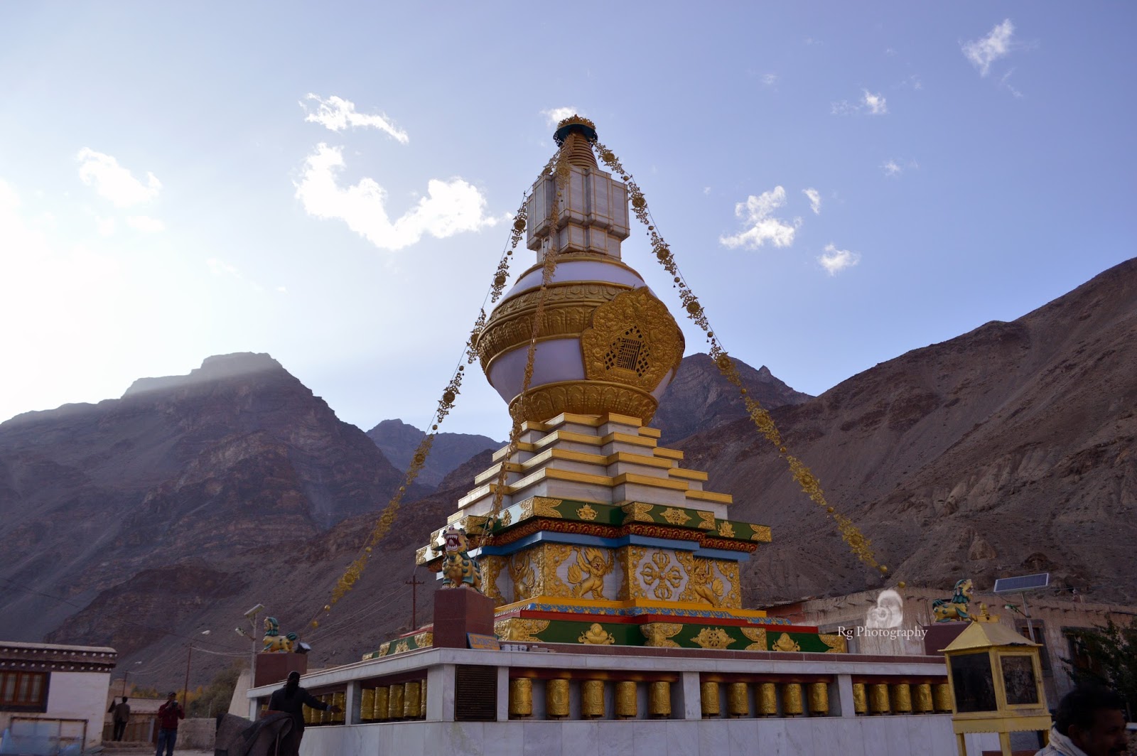
Next we left for Key monastery. The way was just full of mountains and valleys.. beautiful view which one cant miss to see.
Key Gompa (also spelled Ki, Key or Kee - pronounced like English key) is a Tibetan Buddhist monastery located on top of a hill at an altitude of 4,166 metres (13,668 ft) above sea level, close to the Spiti River, in the Spiti Valley of Himachal Pradesh, Lahaul and Spiti district, India. It is the biggest monastery of Spiti Valley and a religious training centre for Lamas. It reportedly had 100 monks in 1855. The walls of the monastery are covered with paintings and murals, an example of the 14th century monastic architecture, which developed as the result of Chinese influence. Key monastery has a collection of ancient murals and books, including Buddha images.
There are three floors, the first one is mainly underground and used for storage. One room, called the Tangyur is richly painted with murals. The ground floor has the beautifully decorated Assembly Hall and cells for many monks. Kye Gompa now belongs to the Gelugpa sect, along with Tabo Monastery and Dhankar Gompa, one of three in Spiti. We passed through the main entrance and welcomed by a set of prayer wheels. We rotated the prayer wheels and moved further to an inner courtyard. we went o a prayer hall through a series of narrow steps. There was a huge picture of Buddha, where we offered our prayers. The monastery has a collection of ancient murals and books of high aesthetic value and it enshrines Buddha images and idols, in the position of Dhyana.
From there, we went to the roof of the monastery. It is an amazing site. One side is covered by the high hills of Himalayas and other side is covered by the Spiti river valley. Visiting Key Monastery was a wonderful experience. We stared our journey back to Kaza. We went to the Kibber village too. We stopped to capture some beautiful scene and photo pictures while passed through the Key village and along the Spiti river and finally reached Kaza.
Back to the hotel..and had good rest!
Day 7:
After breakfast,started the trip to Langza. Langza village situated at an altitude of 4400 meters is divided into 2 sections, namely Langza Yongma (Lower) and Langza Gongma (upper). This Homogeneous Buddhist village belongs to the Sakyapa sect of Tibetan Buddhism.
Langza houses a population of 137 in 33 households. The mainstay of this village in the olden days was mud craft. Vessels of all shapes and sizes were produced here and supplied to the entire valley for household use. This craft has dwindled over the ages and the current mainstay is primarily to agriculture. The village is adorned by an ancient Lang (Temple) estimated to be around 1000 years old. The Lang is regarded as the headquarters of all the devtas (Deities) of the Spiti Valley.
A large modern Buddha statue, built from 2002 to 2005, stares across the Spiti valley from the top of the village; the temple behind it is around 500 years old. Langza is also well known for its rich fossil reserves. Millions of years ago, Spiti lay submerged under the Tethys sea. Fossils of sea life can easily be found scattered close to the village. Regular fossil excursions are organized for a unique insight into the history of the Himalayas.
From there we left to Komic monastry. Komic monastery also known as the Tnagyud Monastery has the honor of being the world’s highest motorable monastery at 4587 mts overlooking the Komic village and mountain peaks. There are a few stories behind the existence of this monastery and they go like this:-
A) As per the sacred ‘Gum Maro’ (Red Box) kept in the monastery, it was foretold in Tibet that a monastery would be built in Spiti in the backdrop of a mountain with the shape of a snow lion on the left and a beheaded eagle on the right hand side with 4 springs in the vicinity. The area in between these mountains was to be in the shape of the eye of a snow cock, which was foretold as the exact location where the Monastery would be built. On the basis of this, the area was to be named Komic (‘Ko’– Snow Cock, ‘Mic’– Eye). The monastery is known as the Komic Lundup Tsemo Gompa and dates to the early 14th century built like a fortified castle with massive slanted mud walls and battlements with vertical red ochre and white vertical stripes. Prayer flags and mountain ranges from Komic Prayer flags and mountain ranges from Komic
B) Due to a drought, the monks of Komic decided to shift the Komic monastery to the nearby, relatively lower-lying village of Hikkim. The Mahakal statue, believed to symbolize the Protector of Dharma, however, refused to move from its foundation in the ground of Komic, despite numerous chipping and lifting efforts by the monks. When the entire monastery moved to Hikkim, the statue remained adamant at Komic, together with one monk who would continue to pray before it. In 1975 or earlier, an earthquake rocked the high altitude villages of Spiti, reducing the Hikkim monastery to ruins, still visible atop a small hill. The Mahakala statue in Komic held its ground even amid the devastating tremors. Convinced that Komic was the holiest place for a monastery, the monks decided to move back to Komic, where the monastery stands to this day. Females are not allowed in the section where the statue of Mahakala is kept.
C) Legend has it that many hundreds of years ago, robbers tried to steal the main deity from the Komic Gompa. The deity although not more than 3 feet in height became so heavy once taken out from the gompa, that the robbers had to abandoned the deity and it was brought back to the gompa. It remains here till this date in the old prayer hall. The gompa also has some hidden treasures which due to security reasons are made public once every 60 years. These are the egg of a dragon, the horn of a unicorn, the upper tooth of a sheep, the ribcage of a gaint demon and the tail of a prehistoric man. The monastery is part of of the Sakya sect of Buddhism. The Sakya Monastery in Kaza is part of the Komic Monastery and was built many years after Komic. In Komic, there are only about a dozen houses with the total population being between 50-60 people. Other than this, there are the Lamas staying at the monastery throughout the year.
When we went,there was a festival that day. Monks were chanting prayers and the people were all dressed up to perform their dances. Local lunch was served to all. Later on the way back, we saw herd of Himalayan blue sheeps or Bhatal as it is called. The landscape on the way back was very beautiful. Overnight stayed at Kaza.
After reaching hotel, few went for local shopping. and then we were served local food. it was very tasty. One must try the local food.
Day 8:
Next day after breakfast, checked out the hotel and started our journey towards Kunzum pass. The way was asusual beautiful with moutains and with the sunrise it made all the more beautiful view with the fog, clouds. We kept clicking pictures. Had to go through so many mountains..ups and downs! Many motorists can be seen on the way.
The road over the pass is not a road. Just a dirt track leading upto the top of the hill. It links the Kullu Valley and Lahaul Valley with the Spiti Valley of Himachal Pradesh. The surface on this gravel road is often loose, especially along the sides of the road. It makes necessary to drive carefully and slow down whenever approaching an oncoming car.The drive is definitely worth it!!
Situated at 4,551 m above mean sea level, Kunzum La or Kunzum Pass is one of the gateways to Lahaul and Spiti valleys. It is one of India’s highest motorable mountain passes and is located in Himachal Pradesh. Separating Spiti and Lahaul valleys, it is situated at a higher altitude than Rohtang Pass, which is at an elevation of 13,054 ft and also serves as another gateway to Lahaul and Spiti. Popular with tourists visiting Lahaul, Spiti and Manali, Kunzum Pass offers spectacular views of Bara-Sigri, the second longest glacier in the world. Also visible from the top of the pass are the Chandra-Bhaga mountain and Spiti valley. The presence of chortens and prayer flags signify a strong Buddhist influence in the area.
Also popular, is the Kunzum Devi Temple where all vehicles must stop to pay respects to the goddess. Three chortens and Kunzum Mata Temple ( SE Structure next to Chortens ) mark the Kumzum La (La means mountain pass in Tibetan language) at a height of 4551m. The old road to Batal goes through this shrine and joins the new road a km down.
The basic structure of a Chorten consist of a square foundation symbolizing the earth, a dome symbolizing water, and thirteen tapering steps of enlightenment symbolizing the element of fire. These steps lead to a stylized parasol, the symbol of wind, which is topped in the ethereal sphere by the well-known ‘twin-symbol’ uniting sun and moon, which is the shimmering crown of the Chorten.
Chandra Taal (meaning the Lake of the Moon), or Chandra Tal is situated in the Spiti part of the Lahul and Spiti. The name of the lake originates from its crescent shape. It is situated at an altitude of about 4,300 metres (14,100 ft) in the Himalayas. Mountains of scree overlook the lake on one side, and a magnificent cirque presents a view on the other. Chandra Taal is a popular destination for trekkers and campers. The lake is situated on the Samudra Tapu plateau, which overlooks the Chandra River.
The lake got its name because of its crescent shape. It is believed, Chandratal was discovered by traders who came to the region from Tibet or Ladakh. After an arduous journey, the traders used to rest near the lake before resuming their journey to Kullu or Spiti.
The sweet water lake is around 2.5 km wide. It is the source of Chandra River which merges with Bhaga River to form Chandrabhaga River and later assumes the identity of Chenab.
The lake is normally blue but changes colour with the colour of the sky. Chandra Bhaga mountain range (CB Group) forms the perfect backdrop for the lake. Though the place is barren and bereft of any human settlement, it is a famous camping site during summer. Travelers often get awestruck by the blue colour of the lake, bordered by wide carpet of green grass coupled with the pristine white of Chandra Bhaga mountain range.
According to Hindu mythology, Chandratal is the place where Indra, the King of Gods, came down on his chariot to transport Yudhishthira, eldest of the five Pandavas, in his mortal form to Swarga (heaven). Locals believe that fairies visit the lake at night.
Another legend has it that Chandra was the beloved daughter of the moon and Bhaga was the only son of Suryadev, the Sun god. Both of them once ran into each other at Baralacha La and it was love at first sight however their love was not approved by their parents and they were not allowed to marry each other. Sun god wanted to entrust his son the task of bringing light to the world in the form of days while Moon god wanted to assign the job of lighting the nights in the world to his daughter Chandra. This disapproval of their parents broke the hearts of the two young lovers but they were not so easily defeated. Together they both decided to elope, meet at Baralacha Pass again where they had first met and perform their eternal marriage themselves without their parent’s approval.
They both came down to the agreed spot but Chandra reached a little ahead of time than Bhaga. When she didn’t find Bhaga at Baralacha La, she wandered off in search for him towards Kunzum Pass and then started to circle back to Baralacha La again. Just when she reached Tandi, she saw Bhaga coming down from the opposite direction looking for her. They both consequently met and the celestial marriage was performed. The route that Chandra took from Baralacha La Pass to Chandra Taal is today present in form of a trek route that several trekking enthusiasts follow. Her route from Kunzum Pass back towards Baralacha La is where the river flows in present days. Chandratal is believed to be named after Chandra and Suraj Taal after Bhaga, him being the son of Sun God. And so is the legend of Chandra Taal, the beautiful lake, tiny in size but a giant in beauty.
We reached the camping ground. From the camping grounds the lake is still about 3km way. You can take the trek route and walk to the lake. Or you can go by vehicle to what is known as the ‘parking lot’ of the Chandratal. From the parking lot, the lake is a 20 minutes leisurely walk.
Chandratal appeared before the eyes like a bowl filled with blue water from a vestibule like opening. Its color was turquoise blue, water was absolutely still. As we move closer, we could see the clearer water on its banks. My heart and mind were locked by the visuals in front of me. No matter how many pictures you see of Himalayan lakes, the magic on standing next to them is something no technology can ever replicate for us. But still we do click pictures!!
The circumference or parikrama of the lake is about 4 km’s. A lot of people, especially Buddhists take a Parikrama (a clockwise circumambulation) around the lake.
At places, we met the piles of stones that Buddhist believers put as a way of marking the path for those who follow. Every passerby puts a stone on top, like adding his bit of the good karma. I later learned that these piles of stones are called ‘Ovoos’.
The path twisted and turned and we saw the part of Chandratal that was not visible from the edge we began our journey from. We stopped frequently to click pictures but no camera can ever match our eyes. I was just taking the landscape into myself.. I knew it would stay with me forever – as a small part of me, some journeys are meant to be like that!
There was a path with big stones that seem to be arranged by human intervention in a manner that made it easy to walk on that stretch. I had spring in my feet as I walked around Chandratal. My breathing that was definitely not effortless in the whole of Spiti valley was absolutely effortless on this parikrama. Legs just moved in a rhythm feeling no strain whatsoever. My body lost its weight and I moved like a ‘Hawa ka Jhonka’ – a gust of wind – feeling effortless, weightless and detached from the rest of the world. I do not know where that energy came from – an obvious answer is that Chandratal gave me that energy.
In the evening, we sat with Bishan Thakur ji, the owner of Parasol Camps over a bowl of garlic soup. And heard stories of Snow Leopards who live in these ranges but are hardly sighted these days.
After simple dinner, we got into our tents with no intention to get out before the sun was up. But, it was so cold we couldnt sleep. Just to see how the outside world looks like stepped out of the tent. When looked at the sky....stars were hanging from the sky like in a well lit Shamiyana and that was all we could see around us. They were not in the sky, they were hanging from it. They were twinkling so brightly that I never felt the absence of moon that night. It was freezing cold, but the sky was in party mode, shining bright and inviting to join in. They were not just shining brightly, they were just too many in number and the whole sky was densely filled with stars. Took few night pictures of the stars..but more than that, enjoyed the view and that feeling which cant be captured by any technology!
Chandratal gave me those magical moments that are etched on my soul. And the night sky gave me the visual that I still feel is straight out of the dreams.
Day 9:
Next morning, got up before sunrise and went to see out. The view of the place changed as the sun rose on the snow capped mountains.
After breakfast, it was time to leave Chandratal and the valleys of Spiti and take the route of Rohtang Pas. We halted at Chandra Dhaba run by Chacha and Chachi for a tea break. The way was full of stones and few streams flowing here and there. The mountains and landscape were barren as we crossed Chotadhara.
Next day after breakfast, checked out the hotel and started our journey towards Kunzum pass. The way was asusual beautiful with moutains and with the sunrise it made all the more beautiful view with the fog, clouds. We kept clicking pictures. Had to go through so many mountains..ups and downs! Many motorists can be seen on the way.
The road over the pass is not a road. Just a dirt track leading upto the top of the hill. It links the Kullu Valley and Lahaul Valley with the Spiti Valley of Himachal Pradesh. The surface on this gravel road is often loose, especially along the sides of the road. It makes necessary to drive carefully and slow down whenever approaching an oncoming car.The drive is definitely worth it!!
Situated at 4,551 m above mean sea level, Kunzum La or Kunzum Pass is one of the gateways to Lahaul and Spiti valleys. It is one of India’s highest motorable mountain passes and is located in Himachal Pradesh. Separating Spiti and Lahaul valleys, it is situated at a higher altitude than Rohtang Pass, which is at an elevation of 13,054 ft and also serves as another gateway to Lahaul and Spiti. Popular with tourists visiting Lahaul, Spiti and Manali, Kunzum Pass offers spectacular views of Bara-Sigri, the second longest glacier in the world. Also visible from the top of the pass are the Chandra-Bhaga mountain and Spiti valley. The presence of chortens and prayer flags signify a strong Buddhist influence in the area.
Also popular, is the Kunzum Devi Temple where all vehicles must stop to pay respects to the goddess. Three chortens and Kunzum Mata Temple ( SE Structure next to Chortens ) mark the Kumzum La (La means mountain pass in Tibetan language) at a height of 4551m. The old road to Batal goes through this shrine and joins the new road a km down.
The basic structure of a Chorten consist of a square foundation symbolizing the earth, a dome symbolizing water, and thirteen tapering steps of enlightenment symbolizing the element of fire. These steps lead to a stylized parasol, the symbol of wind, which is topped in the ethereal sphere by the well-known ‘twin-symbol’ uniting sun and moon, which is the shimmering crown of the Chorten.
From Kunzum pass, we left for Chandratal lake. The road to Spiti has more mud and rocks than anything else! There is hardly any tar to be seen anywhere! You can find waterfalls, pagal nalas all on the road!
Chandra Taal (meaning the Lake of the Moon), or Chandra Tal is situated in the Spiti part of the Lahul and Spiti. The name of the lake originates from its crescent shape. It is situated at an altitude of about 4,300 metres (14,100 ft) in the Himalayas. Mountains of scree overlook the lake on one side, and a magnificent cirque presents a view on the other. Chandra Taal is a popular destination for trekkers and campers. The lake is situated on the Samudra Tapu plateau, which overlooks the Chandra River.
The lake got its name because of its crescent shape. It is believed, Chandratal was discovered by traders who came to the region from Tibet or Ladakh. After an arduous journey, the traders used to rest near the lake before resuming their journey to Kullu or Spiti.
The sweet water lake is around 2.5 km wide. It is the source of Chandra River which merges with Bhaga River to form Chandrabhaga River and later assumes the identity of Chenab.
The lake is normally blue but changes colour with the colour of the sky. Chandra Bhaga mountain range (CB Group) forms the perfect backdrop for the lake. Though the place is barren and bereft of any human settlement, it is a famous camping site during summer. Travelers often get awestruck by the blue colour of the lake, bordered by wide carpet of green grass coupled with the pristine white of Chandra Bhaga mountain range.
According to Hindu mythology, Chandratal is the place where Indra, the King of Gods, came down on his chariot to transport Yudhishthira, eldest of the five Pandavas, in his mortal form to Swarga (heaven). Locals believe that fairies visit the lake at night.
Another legend has it that Chandra was the beloved daughter of the moon and Bhaga was the only son of Suryadev, the Sun god. Both of them once ran into each other at Baralacha La and it was love at first sight however their love was not approved by their parents and they were not allowed to marry each other. Sun god wanted to entrust his son the task of bringing light to the world in the form of days while Moon god wanted to assign the job of lighting the nights in the world to his daughter Chandra. This disapproval of their parents broke the hearts of the two young lovers but they were not so easily defeated. Together they both decided to elope, meet at Baralacha Pass again where they had first met and perform their eternal marriage themselves without their parent’s approval.
They both came down to the agreed spot but Chandra reached a little ahead of time than Bhaga. When she didn’t find Bhaga at Baralacha La, she wandered off in search for him towards Kunzum Pass and then started to circle back to Baralacha La again. Just when she reached Tandi, she saw Bhaga coming down from the opposite direction looking for her. They both consequently met and the celestial marriage was performed. The route that Chandra took from Baralacha La Pass to Chandra Taal is today present in form of a trek route that several trekking enthusiasts follow. Her route from Kunzum Pass back towards Baralacha La is where the river flows in present days. Chandratal is believed to be named after Chandra and Suraj Taal after Bhaga, him being the son of Sun God. And so is the legend of Chandra Taal, the beautiful lake, tiny in size but a giant in beauty.
We reached the camping ground. From the camping grounds the lake is still about 3km way. You can take the trek route and walk to the lake. Or you can go by vehicle to what is known as the ‘parking lot’ of the Chandratal. From the parking lot, the lake is a 20 minutes leisurely walk.
Chandratal appeared before the eyes like a bowl filled with blue water from a vestibule like opening. Its color was turquoise blue, water was absolutely still. As we move closer, we could see the clearer water on its banks. My heart and mind were locked by the visuals in front of me. No matter how many pictures you see of Himalayan lakes, the magic on standing next to them is something no technology can ever replicate for us. But still we do click pictures!!
The circumference or parikrama of the lake is about 4 km’s. A lot of people, especially Buddhists take a Parikrama (a clockwise circumambulation) around the lake.
At places, we met the piles of stones that Buddhist believers put as a way of marking the path for those who follow. Every passerby puts a stone on top, like adding his bit of the good karma. I later learned that these piles of stones are called ‘Ovoos’.
The path twisted and turned and we saw the part of Chandratal that was not visible from the edge we began our journey from. We stopped frequently to click pictures but no camera can ever match our eyes. I was just taking the landscape into myself.. I knew it would stay with me forever – as a small part of me, some journeys are meant to be like that!
There was a path with big stones that seem to be arranged by human intervention in a manner that made it easy to walk on that stretch. I had spring in my feet as I walked around Chandratal. My breathing that was definitely not effortless in the whole of Spiti valley was absolutely effortless on this parikrama. Legs just moved in a rhythm feeling no strain whatsoever. My body lost its weight and I moved like a ‘Hawa ka Jhonka’ – a gust of wind – feeling effortless, weightless and detached from the rest of the world. I do not know where that energy came from – an obvious answer is that Chandratal gave me that energy.
Felt no exhaustion, tiredness from that mini 4 km’s trek around the lake. I was amazed at the sudden surge of energy in both my body and my soul. Was I in touch with some higher energies that got channeled through me for those couple of hours. I have no doubt it happened. I am not sure if I would ever be able to find words that describe those hours for me. As soon as we finished the Parikrama and we had to walk back to the car, I felt the same gravitational pull. And I needed all the energy to push myself to reach the car. While walking back, I almost felt that I left my magic wand at Chandratal Lake.
In the evening, we sat with Bishan Thakur ji, the owner of Parasol Camps over a bowl of garlic soup. And heard stories of Snow Leopards who live in these ranges but are hardly sighted these days.
After simple dinner, we got into our tents with no intention to get out before the sun was up. But, it was so cold we couldnt sleep. Just to see how the outside world looks like stepped out of the tent. When looked at the sky....stars were hanging from the sky like in a well lit Shamiyana and that was all we could see around us. They were not in the sky, they were hanging from it. They were twinkling so brightly that I never felt the absence of moon that night. It was freezing cold, but the sky was in party mode, shining bright and inviting to join in. They were not just shining brightly, they were just too many in number and the whole sky was densely filled with stars. Took few night pictures of the stars..but more than that, enjoyed the view and that feeling which cant be captured by any technology!
Chandratal gave me those magical moments that are etched on my soul. And the night sky gave me the visual that I still feel is straight out of the dreams.
Day 9:
Next morning, got up before sunrise and went to see out. The view of the place changed as the sun rose on the snow capped mountains.
After breakfast, it was time to leave Chandratal and the valleys of Spiti and take the route of Rohtang Pas. We halted at Chandra Dhaba run by Chacha and Chachi for a tea break. The way was full of stones and few streams flowing here and there. The mountains and landscape were barren as we crossed Chotadhara.
It was evening by the time we reached Rotang pass. Back to the living world.. and the normal roads. Rohtang , (means.. pile of corpses,due to people dying in bad weather trying to cross the pass) (elevation 3,978 m (13,050 ft)), is a high mountain pass on the eastern Pir Panjal Range of the Himalayas around 51 km (32 mi) from Manali. It connects the Kullu Valley with the Lahaul and Spiti Valleys of Himachal Pradesh.
On the way saw paragliding but we were all tired and in no mood to adventure anything. Reached Manali and checked into hotel Mayflower. Had hot tea and refreshed. Next day morning we all had our flights from Kullu. Felt very exhausted and after dinner just hit the bed.
Day 10:
Morning all got up early, packed things and set for the last road trip to Kullu airport.
Thus, ends the trip with loads of memories.
Thanks to wowclub for this trip. It was a great experience.
Thanks to himcalling team for their guidance and care of the group.
Suryadeo Temple and Mando Devi Temple is very famous destination in Gondia. One should thing of visiting the place with family, friends etc.
ReplyDelete